(One intermediate revision by the same user not shown)
Line 8:
Line 8:
{| class="wikitable"
{| class="wikitable"
|-\n|1||[[Blood%27s%20Hotel|Blood's Hotel]], later the [[Riverside%20Inn|Riverside Inn]]|\n|-\n|2||[[Spaulding%20Block|Spaulding Block]]|\n|-\n|3||[[Seaver%20A.%20Miller%20Cottage|Seaver A. Miller Cottage]]|\n|-\n|4||St. Nicholas Hotel (later the [[Empire%20Hotel|Empire Hotel]])|\n|-\n|5||35/37 Main Street, [[National%20Express%20Office|National Express Office]], later [[Kendall%27s%20Grocery|Kendall's Grocery]] |\n|-\n|6||43 Main Street, a grocery (now the [[Waterhole|Waterhole]])? |\n|-\n|7||[[Linwood%20Cottage|Linwood Cottage]]|\n|-\n|8|| |\n|-\n|9|| |\n|-\n|10||48 Main Street ([[Little%20Joe%27s|Little Joe's]]) |\n|-\n|11||[[Mrs.%20Lucius%20Evans%20Cottage|Mrs. Lucius Evans Cottage]] ?|\n|-\n|12||[[Frederick%20A.%20Isham|Frederick A. Isham]]|\n|-\n|13||[[Berkeley%20House|Berkeley House]]|\n|-\n|14||The Academy for which [[Academy%20Street|Academy Street]] is named|\n|-\n|15||[[Methodist%20Church|Methodist Church]]|\n|-\n|16||[[Guild%20House|Guild House]] |\n|-\n|17||[[Lawrason%20Brown%20Office%20and%20Residence|Lawrason Brown Office and Residence]] (before Brown came to town)|\n|-\n|18||[[Ensine%20Miller|Ensine Miller]]'s house, [[Sunnyside|Sunnyside]], where the William Morris playground is today|\n|-\n|19||The first [[Edward%20Livingston%20Trudeau%20house%20and%20office|Edward Livingston Trudeau house and office]] had just been built; it would burn (and be rebuilt) in 1894|\n|-\n|20||[[St.%20Luke%27s%20Church|St. Luke's Church]]|\n|-\n|21||Future site of the [[Baldwin%20House|Baldwin House]]|\n|-\n|22||[[Charles%20M.%20Lea%20House|Charles M. Lea House]]|\n|-\n|23||[[Helen%20Hill|Helen Hill]]|\n|-\n|24||Future site of the [[Adirondack%20Cottage%20Sanatorium|Adirondack Cottage Sanatorium]]|\n|-\n|25||Future site of [[Park%20Avenue|Park Avenue]]|\n|-\n|26||[[Adirondack%20Bottling%20Works|Adirondack Bottling Works]]|\n|-\n|27||[[Pliny%20Miller%27s%20Sawmill%20and%20Gristmill|Pliny Miller's Sawmill and Gristmill]]|\n|-\n|28||Future site of [[Harrietstown%20Town%20Hall|Harrietstown Town Hall]]|\n|-\n|29||[[Fowler%27s%20Livery|Fowler's Livery]]|\n</tbody>
|-
|}
|1||[[Blood%27s%20Hotel|Blood's Hotel]], later the [[Riverside%20Inn|Riverside Inn]]
|-
|2||[[Spaulding%20Block|Spaulding Block]]
|-
|3||[[Seaver%20A.%20Miller%20Cottage|Seaver A. Miller Cottage]]
|-
|4||St. Nicholas Hotel (later the [[Empire%20Hotel|Empire Hotel]])
|-
|5||35/37 Main Street, [[National%20Express%20Office|National Express Office]], later [[Kendall%27s%20Grocery|Kendall's Grocery]]
|-
|6||43 Main Street, a grocery (now the [[Waterhole|Waterhole]])?
|-
|7||[[Linwood%20Cottage|Linwood Cottage]]
|-
|8||
|-
|9||
|-
|10||48 Main Street ([[Little%20Joe%27s|Little Joe's]])
|-
|11||[[Mrs.%20Lucius%20Evans%20Cottage|Mrs. Lucius Evans Cottage]] ?
|-
|12||[[Frederick%20A.%20Isham|Frederick A. Isham]]
|-
|13||[[Berkeley%20House|Berkeley House]]
|-
|14||The Academy for which [[Academy%20Street|Academy Street]] is named
|-
|15||[[Methodist%20Church|Methodist Church]]
|-
|16||[[Guild%20House|Guild House]]
|-
|17||[[Lawrason%20Brown%20Office%20and%20Residence|Lawrason Brown Office and Residence]] (before Brown came to town)
|-
|18||[[Ensine%20Miller|Ensine Miller]]'s house, [[Sunnyside|Sunnyside]], where the William Morris playground is today
|-
|19||The first [[Edward%20Livingston%20Trudeau%20house%20and%20office|Edward Livingston Trudeau house and office]] had just been built; it would burn (and be rebuilt) in 1894
|27||[[Pliny%20Miller%27s%20Sawmill%20and%20Gristmill|Pliny Miller's Sawmill and Gristmill]]
|-
|28||Future site of [[Harrietstown%20Town%20Hall|Harrietstown Town Hall]]
|-
|29||[[Fowler%27s%20Livery|Fowler's Livery]]
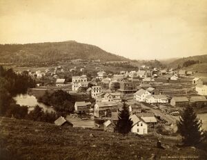
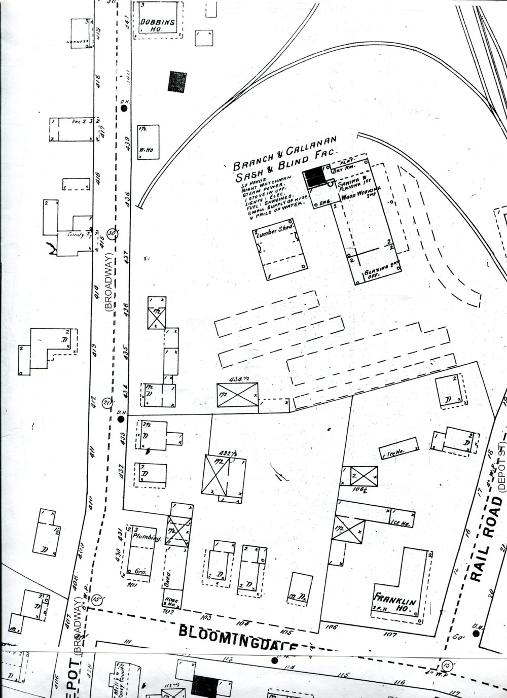
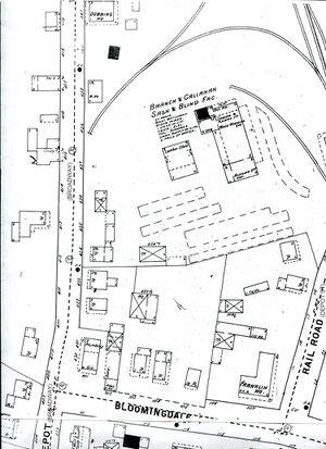
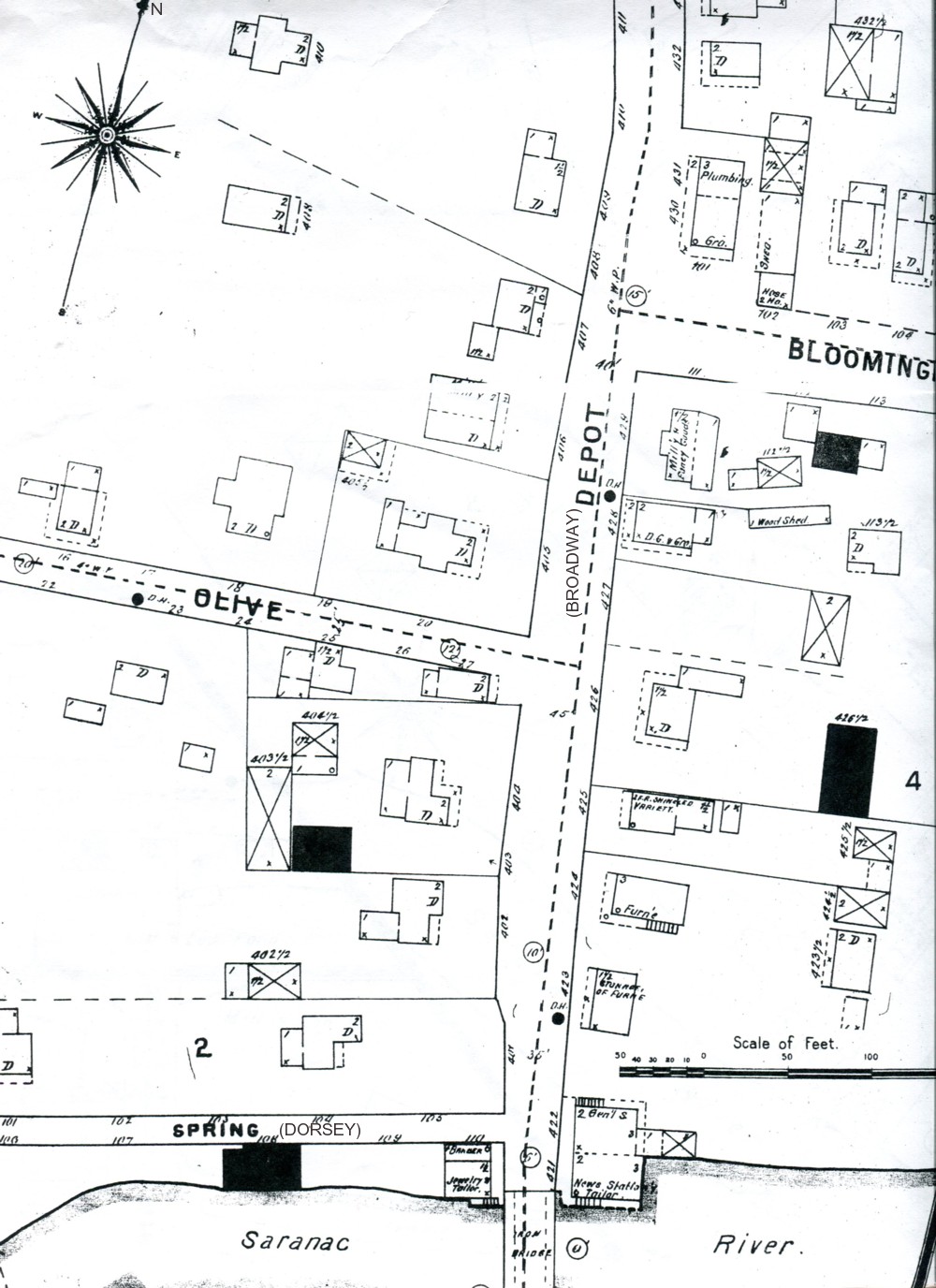
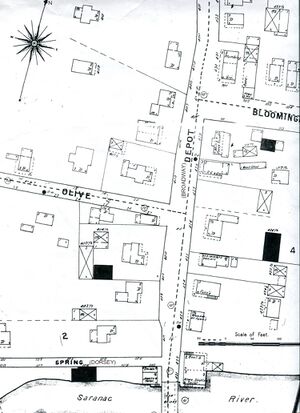
'''''The following [[Sanborn%20Maps|Sanborn Maps]] of the village are dated 1895, about ten years later than the photograph. They are the earliest available. Note that today's Broadway was named Depot Street at the time, for the New York Central Depot located across the tracks from today's Kinney Drugs.''''' [[File:Sanborn%20map%20Bloomingdale%20Av.jpg|left|]]</img>[[File:Sanborn%20map%20Bloomingdale%20Av.jpg|left|thumb||The earliest [[Sanborn%20Map|Sanborn Map]]| of Saranac Lake, [[Broadway|Broadway]]| and [[Bloomingdale%20Avenue|Bloomingdale Avenue]]|, 1895 ]] [[File:Sanborn%20map%20Broadway.jpg|left|]]</img>[[File:Sanborn%20map%20Broadway.jpg|left|thumb||The earliest [[Sanborn%20Map|Sanborn Map]]| of Saranac Lake, south [[Broadway|Broadway]]|, 1895 ]] </h3><h3>
|}'''''The following [[Sanborn%20Maps|Sanborn Maps]] of the village are dated 1895, about ten years later than the photograph. They are the earliest available. Note that today's Broadway was named Depot Street at the time, for the New York Central Depot located across the tracks from today's Kinney Drugs.''''' [[File:Sanborn%20map%20Bloomingdale%20Av.jpg|left|]]</img>[[File:Sanborn%20map%20Bloomingdale%20Av.jpg|left|thumb||The earliest [[Sanborn%20Map|Sanborn Map]]| of Saranac Lake, [[Broadway|Broadway]]| and [[Bloomingdale%20Avenue|Bloomingdale Avenue]]|, 1895 ]] [[File:Sanborn%20map%20Broadway.jpg|left|]]</img>[[File:Sanborn%20map%20Broadway.jpg|left|thumb||The earliest [[Sanborn%20Map|Sanborn Map]]| of Saranac Lake, south [[Broadway|Broadway]]|, 1895 ]] </h3><h3>
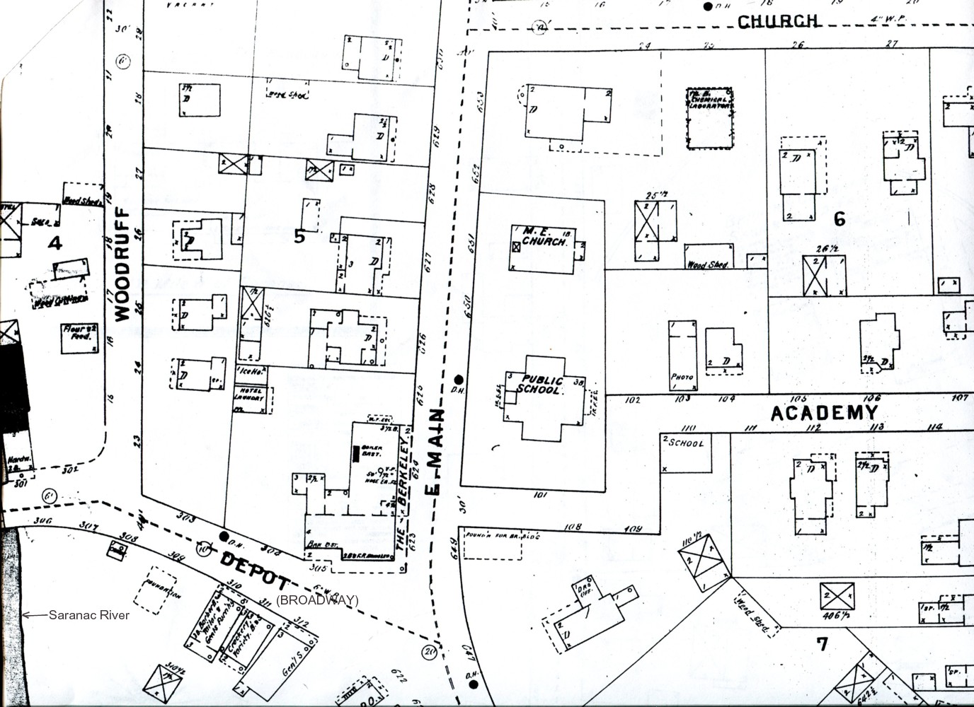
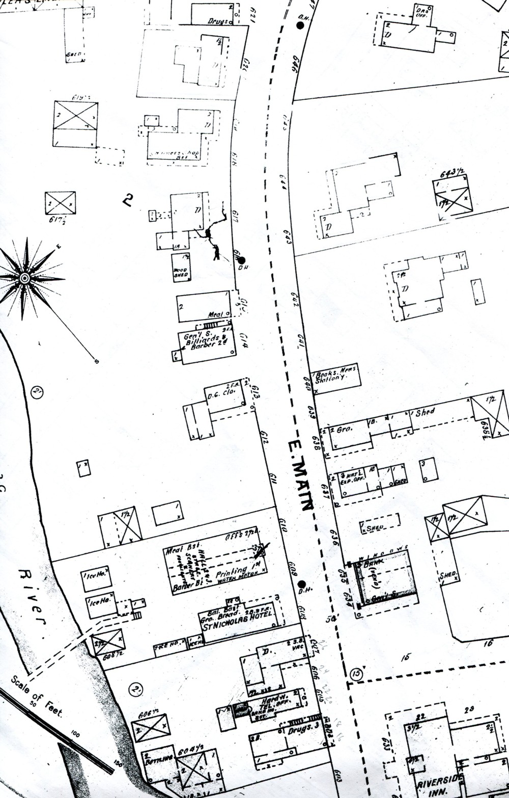
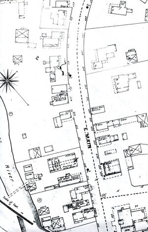
'''''Note: The orientation of the following two maps does not match the ones above.''''' North is approximately at top, above, to the right on the map immediately below, and as indicated on the last map. [[File:Sanborn%20map%20Berkeley.jpg|left|]]</img>[[File:Sanborn%20map%20Berkeley.jpg|left|thumb||The earliest [[Sanborn%20Map|Sanborn Map]]| of Saranac Lake, [[Main%20Street|Main Street]]| and [[Broadway|Broadway]]|, 1895 ]] [[File:Sanborn%20map%20Main%20St.jpg|left|]]</img>[[File:Sanborn%20map%20Main%20St.jpg|left|thumb||The earliest [[Sanborn%20Map|Sanborn Map]]| of Saranac Lake's southern [[Main%20Street|Main Street]]|, 1895 ]] </h3>
'''''Note: The orientation of the following two maps does not match the ones above.''''' North is approximately at top, above, to the right on the map immediately below, and as indicated on the last map. [[File:Sanborn%20map%20Berkeley.jpg|left|]]</img>[[File:Sanborn%20map%20Berkeley.jpg|left|thumb||The earliest [[Sanborn%20Map|Sanborn Map]]| of Saranac Lake, [[Main%20Street|Main Street]]| and [[Broadway|Broadway]]|, 1895 ]] [[File:Sanborn%20map%20Main%20St.jpg|left|]]</img>[[File:Sanborn%20map%20Main%20St.jpg|left|thumb||The earliest [[Sanborn%20Map|Sanborn Map]]| of Saranac Lake's southern [[Main%20Street|Main Street]]|, 1895 ]] </h3>
The following Sanborn Maps of the village are dated 1895, about ten years later than the photograph. They are the earliest available. Note that today's Broadway was named Depot Street at the time, for the New York Central Depot located across the tracks from today's Kinney Drugs.</img>, 1895 </img>, 1895
Note: The orientation of the following two maps does not match the ones above. North is approximately at top, above, to the right on the map immediately below, and as indicated on the last map. </img>, 1895 </img>, 1895