Polliwog Pond: Difference between revisions
Appearance
Migratebot (talk | contribs) Created page with " right|right|thumb||1955 U.S. Geological Service map, St. Regis quadrangle'''Polliwog Pond''' (also spelled Pollywog) is a 185-acre pond just south Floodwood Road and west of Follensby Clear Pond. It is south of the St. Regis Canoe Area on land that is part of the Saranac Lakes Wild Forest. There were a num..." |
Migratebot (talk | contribs) No edit summary |
||
| Line 1: | Line 1: | ||
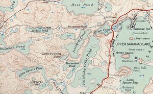
[[File:POLLIWOG.jpg|right|thumb||1955 U.S. Geological Service map, St. Regis quadrangle]]'''Polliwog Pond''' (also spelled Pollywog) is a 185-acre pond just south [[Floodwood%20Road|Floodwood Road]] and west of [[Follensby%20Clear%20Pond|Follensby Clear Pond]]. It is south of the [[St.%20Regis%20Canoe%20Area|St. Regis Canoe Area]] on land that is part of the [[Saranac%20Lakes%20Wild%20Forest|Saranac Lakes Wild Forest]]. | |||
There were a number of Tent Platforms on Polliwog, one of which was held by the [[Russell%20Baker%20Tent%20Platform|Russell Baker family]]. The tent Platforms were discontinued in the 1970s. | There were a number of Tent Platforms on Polliwog, one of which was held by the [[Russell%20Baker%20Tent%20Platform|Russell Baker family]]. The tent Platforms were discontinued in the 1970s. | ||
Latest revision as of 04:43, 17 November 2024

Polliwog Pond (also spelled Pollywog) is a 185-acre pond just south Floodwood Road and west of Follensby Clear Pond. It is south of the St. Regis Canoe Area on land that is part of the Saranac Lakes Wild Forest.
There were a number of Tent Platforms on Polliwog, one of which was held by the Russell Baker family. The tent Platforms were discontinued in the 1970s.