Muzzy Road: Difference between revisions
Appearance
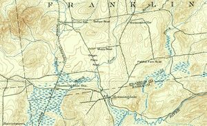
Migratebot (talk | contribs) Created page with " right|right|thumb||Muzzy Road, center<br>|1902 USGS map, Saranac quadrant<br>'''Muzzy Road''' is a 1.1-mile long road leading from Oregon Plains Road to New York Route 3. It was the site of the 100-acre farm of escaped slave John Thomas, c. 1853 to 1894." |
Migratebot (talk | contribs) No edit summary |
||
| Line 1: | Line 1: | ||
[[File:NY_Saranac_129380_1902_62500.jpg|right|thumb||Muzzy Road, center<br>|1902 USGS map, Saranac quadrant]]<br>'''Muzzy Road''' is a 1.1-mile long road leading from [[Oregon%20Plains%20Road|Oregon Plains Road]] to [[New%20York%20Route%203|New York Route 3]]. It was the site of the 100-acre farm of escaped slave John Thomas, c. 1853 to 1894. | |||
Revision as of 20:54, 16 November 2024

Muzzy Road is a 1.1-mile long road leading from Oregon Plains Road to New York Route 3. It was the site of the 100-acre farm of escaped slave John Thomas, c. 1853 to 1894.