Oseetah Lake: Difference between revisions
Migratebot (talk | contribs) Created page with " right|right|thumb|[[McKenzie%20Mountain|McKenzie Mountain| from Oseetah ]] left|left|thumb||Oseetah from [[Ampersand%20Mountain|Ampersand Mountain| ]] left|left|thumb||Oseetah Lake, c. 1920, from an undated brochure by [[E.%20L.%20Gray|E. L. Gray| & Co., c. 1920. Courtesy of Natal..." |
Migratebot (talk | contribs) No edit summary |
||
| Line 1: | Line 1: | ||
[[File:Oseetah.jpg|right|thumb|[[McKenzie%20Mountain|McKenzie Mountain]]| from Oseetah ]] | |||
[[File:Oseetah%20from%20Ampersand.jpg|left|thumb||Oseetah from [[Ampersand%20Mountain|Ampersand Mountain]]| ]] [[File:Oseetah%20c.%201920.jpg|left|thumb||Oseetah Lake, c. 1920, from an undated brochure by [[E.%20L.%20Gray|E. L. Gray]]| & Co., c. 1920. Courtesy of [[Natalie%20Leduc|Natalie Leduc]]|. ]] [[File:Camp%20Juanita%20ad.jpg|right|thumb|''[[Adirondack%20Enterprise|Adirondack Enterprise]]''|, October 1, 1915 ]]'''Oseetah Lake''' (orginally '''Miller Pond''') is a 250-acre lake two-and-a-half miles south of the village of Saranac Lake on the [[Saranac%20River|Saranac River]]. | |||
Oseetah Lake was enlarged when the dam across the Saranac River at Saranac Lake that forms [[Lake%20Flower|Lake Flower]] was raised to generate electric power by the [[Saranac%20Lake%20Electric%20Company|Saranac Lake Electric Company]] in 1904. The Saranac River departs the lower [[locks|locks]] below [[Lower%20Saranac%20Lake|Lower Saranac Lake]] and flows northeast into Oseetah Lake. The river exits Oseetah at the north end of the lake and flows northeast to [[Lake%20Flower|Lake Flower]]. Oseetah is also fed by [[Kiwassa%20Lake|Kiwassa Lake]]. Islands in Oseetah Lake include [[Turtle%20Island|Turtle]], [[Wyota%20Island|Wyota]], [[Wapiti%20Island|Wapiti]], [[Watch%20Island|Watch]], [[Haven%20of%20Rest|Haven of Rest]], [[Papoose%20Island|Papoose]], [[Birch%20Island%2C%20Oseetah%20Lake|Birch]], [[Justamere%20Island|Justamere]], and [[Honeymoon%20Island|Honeymoon]] or [[Newman%27s%20Island|Newman's Island]]. Oseetah's shoreline and islands are mostly privately held. | Oseetah Lake was enlarged when the dam across the Saranac River at Saranac Lake that forms [[Lake%20Flower|Lake Flower]] was raised to generate electric power by the [[Saranac%20Lake%20Electric%20Company|Saranac Lake Electric Company]] in 1904. The Saranac River departs the lower [[locks|locks]] below [[Lower%20Saranac%20Lake|Lower Saranac Lake]] and flows northeast into Oseetah Lake. The river exits Oseetah at the north end of the lake and flows northeast to [[Lake%20Flower|Lake Flower]]. Oseetah is also fed by [[Kiwassa%20Lake|Kiwassa Lake]]. Islands in Oseetah Lake include [[Turtle%20Island|Turtle]], [[Wyota%20Island|Wyota]], [[Wapiti%20Island|Wapiti]], [[Watch%20Island|Watch]], [[Haven%20of%20Rest|Haven of Rest]], [[Papoose%20Island|Papoose]], [[Birch%20Island%2C%20Oseetah%20Lake|Birch]], [[Justamere%20Island|Justamere]], and [[Honeymoon%20Island|Honeymoon]] or [[Newman%27s%20Island|Newman's Island]]. Oseetah's shoreline and islands are mostly privately held. | ||
| Line 17: | Line 17: | ||
----- | ----- | ||
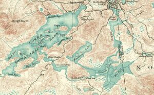
[[File:USGS%20Saranac%20quad%2C1902.jpg|left|thumb||1902 USGS Saranac quad showing Oseetah in relation to Lower Saranac Lake. Note that the original shoreline is shown before later flooding, crosshatched.]]<h3>'''See also'''</h3> | |||
• [[Oseetah%20Lake%20Club|Oseetah Lake Club]] | • [[Oseetah%20Lake%20Club|Oseetah Lake Club]] | ||
| Line 29: | Line 29: | ||
''This article appeared originally on [[http://en.wikipedia.org|Wikipedia]] as [[http://en.wikipedia.org/wiki/Oseetah_Lake|Oseetah Lake"]]; its edit history there reflects its authorship. It is licensed under the [[http://en.wikipedia.org/wiki/Text_of_the_GNU_Free_Documentation_License|GDFL.]]'' | ''This article appeared originally on [[http://en.wikipedia.org|Wikipedia]] as [[http://en.wikipedia.org/wiki/Oseetah_Lake|Oseetah Lake"]]; its edit history there reflects its authorship. It is licensed under the [[http://en.wikipedia.org/wiki/Text_of_the_GNU_Free_Documentation_License|GDFL.]]'' | ||
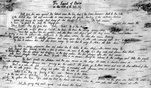
[[File:Legend%20of%20Oseetah.JPG|left|thumb||The Legend of Oseetah written on birch bark. Courtesy of [[Natalie%20Leduc|Natalie Leduc]]]] | |||
## | ## | ||
Latest revision as of 22:40, 16 November 2024
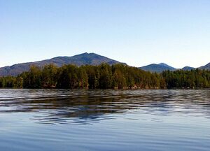
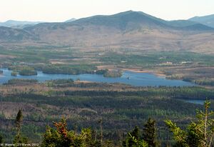
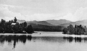

Oseetah Lake (orginally Miller Pond) is a 250-acre lake two-and-a-half miles south of the village of Saranac Lake on the Saranac River.
Oseetah Lake was enlarged when the dam across the Saranac River at Saranac Lake that forms Lake Flower was raised to generate electric power by the Saranac Lake Electric Company in 1904. The Saranac River departs the lower locks below Lower Saranac Lake and flows northeast into Oseetah Lake. The river exits Oseetah at the north end of the lake and flows northeast to Lake Flower. Oseetah is also fed by Kiwassa Lake. Islands in Oseetah Lake include Turtle, Wyota, Wapiti, Watch, Haven of Rest, Papoose, Birch, Justamere, and Honeymoon or Newman's Island. Oseetah's shoreline and islands are mostly privately held.
According to a legend of doubtful authenticity, Oseetah was an Indian Princess who, upon throwing herself off a cliff into a lake on learning the Indian chief she loved was betrothed to another, was magically transformed into a water lily. In the Huron language Oseetah means "Water Lily". 1
It is part of the route of the Adirondack Canoe Classic, also known as the Ninety-miler.
Plattsburgh Press, May 29, 1906
Hon. Benjamin S. Hall, president of the Oseetah Lake Co., is spending several days in town. The village and town officials hare received invitations to accompany Mr. Hall on the initial trip of the launch Indian Maid, from the village to Lower Saranac Lake this week.
See also
References
• A History of the Adirondacks, Alfred L. Donaldson, Harbor Hill Books, 1977
• Topographical Survey, Adirondack Region, Verplanck Colvin, Weed Parsons & Company, 1880
This article appeared originally on [[1]] as [Lake"]; its edit history there reflects its authorship. It is licensed under the [[2]]
- Footnotes
1. Skinner, Charles Montgomery, Myths and legends of our own land', Volume 1