Town of Brighton

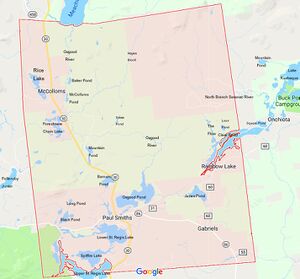
The Town of Brighton covers 8340 square miles in Franklin County, New York, at an altitude averaging 1640 feet. Brighton lies in three different major watersheds: the Saranac/Chazy-Lake Champlain watershed, the St. Regis-St. Lawrence watershed, and the Salmon/Trout-St. Lawrence watershed. Brighton is 26% wetlands and nearly the entire town is underlain by a high-quality aquifer. Many of the wetland areas are home to rare and threatened species such as spruce grouse, moose and three-toed woodpecker.

Approximately 47% of the land in Brighton is state-owned. Paul Smith's College ownership accounts for an additional 20% of town acreage. Within the Town are the small settlements of Gabriels, Keese Mills, Onchiota, Paul Smiths, Rainbow Lake and McColloms.
Leon Redwood served as superintendent of highways in the 1960s.
- Brighton Town Hall
- Brighton Notables
- Brighton Area Guides
- Brighton History Days
- Brighton Curing Timeline
- Curing in Brighton
- How Brighton Got Its Name
- Paul Smith's Hotel
- Paul Smith's Electric Railroad
- Sunnyside Hotel
- St. Gabriel
- First Methodist Episcopal Church of Brighton
- St. Regis Presbyterian
- St. John's in the Wilderness
- Benjamin A. Muncil
- Famous Visitors

History of Clinton and Franklin counties, New York, (1880) p. 398, gives the population of the Town of Brighton as follows:
class="wikitable"The Palladium Malone, Thursday, Dec 19, 1867
Abstracts of Accounts audited by the Board of Town Auditors of the town of Brighton, at their annual session, Nov. 7, 1867:
class="wikitable"- Comments