Sanborn Maps: Difference between revisions
Appearance
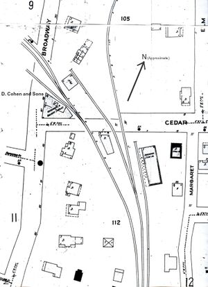
Migratebot (talk | contribs) Created page with " right|right|thumb||The Sanborn map of the [[Berkeley%20Square|Berkeley Square| area, 1908 ]] '''Sanborn Maps''', made by the Sanborn Map Company of Pelham, New York, beginning in 1867, were created for assessing fire insurance liability in urbanized areas in the United States; they include detailed information regarding town and building information. Maps for Saranac Lake exist for 1895, 1899, 1903, 1908, 1916, 1924..." |
Migratebot (talk | contribs) No edit summary |
||
| Line 1: | Line 1: | ||
[[File:Sanborn%20map.jpg|right|thumb||The Sanborn map of the [[Berkeley%20Square|Berkeley Square]]| area, 1908 ]] '''Sanborn Maps''', made by the Sanborn Map Company of Pelham, New York, beginning in 1867, were created for assessing fire insurance liability in urbanized areas in the United States; they include detailed information regarding town and building information. Maps for Saranac Lake exist for 1895, 1899, 1903, 1908, 1916, 1924, 1931, 1945 and 1961; the [[Adirondack%20Research%20Room|Adirondack Research Room]] of the [[Saranac%20Lake%20Free%20Library|Saranac Lake Free Library]] has copies. | |||
The maps are quite detailed for the areas that they cover, showing in outline the shape of each structure, and indicating the number of floors of each section, including porches. However, they never cover the entire village. Areas covered, by year, include: | The maps are quite detailed for the areas that they cover, showing in outline the shape of each structure, and indicating the number of floors of each section, including porches. However, they never cover the entire village. Areas covered, by year, include: | ||
Latest revision as of 05:27, 17 November 2024

Sanborn Maps, made by the Sanborn Map Company of Pelham, New York, beginning in 1867, were created for assessing fire insurance liability in urbanized areas in the United States; they include detailed information regarding town and building information. Maps for Saranac Lake exist for 1895, 1899, 1903, 1908, 1916, 1924, 1931, 1945 and 1961; the Adirondack Research Room of the Saranac Lake Free Library has copies.
The maps are quite detailed for the areas that they cover, showing in outline the shape of each structure, and indicating the number of floors of each section, including porches. However, they never cover the entire village. Areas covered, by year, include:
- 1895 - 2 pages: only the core of the business district
- 1899 - 4 pages: the River Street, Church Street, St. Bernard Street triangle is added, along with the Main Street, Church Street, Helen Street, Front Street block and Adirondack Cottage Sanitarium
- 1903 - 5 pages: essentially the same coverage as 1899
- 1908 - 8 pages: Helen Hill and more of River Street added.
- 1916 - 10 pages: part of French Hill and more of North Broadway added
- 1924 - 15 pages: more of River Street and part of Lake Flower Avenue, more of north Broadway and Ampersand Avenue, more of French Hill, Park Avenue, Margaret Street and Baker Street added
- 1931 - 18 pages: more of River Street, part of Pontiac Street, Slater Avenue, Winona Avenue and Lake Flower Avenue, more of North Broadway added.
- 1945
- 1962
External link:
- The 1895 and 1899 map sets are [online at the Library of Congress]